.avif)


Connecting the dots: regional assessment of landscape connectivity in amphibian communities in Central Spain
Habitat loss and fragmentation, driven by urban growth and land transformation, are among the primary threats to global biodiversity. This issue particularly affects groups like amphibians, whose biology depends on well-connected aquatic and terrestrial habitats. Without functional corridors, many populations become isolated, putting their long-term survival at risk.
Our Biodiversity technical team has had the opportunity to analyze in depth the study recently published in Landscape Ecology on July 21, 2025. This work, which focuses on landscape connectivity for amphibian communities in central Spain—specifically in the Community of Madrid—was developed by authors Carlos Caballero Díaz (UAM), Pedro Tarroso, Gregorio Sánchez-Montes, Ismael Reyes Moya, Nuria Polo Cavia (UAM), and Iñigo Martínez Solano.
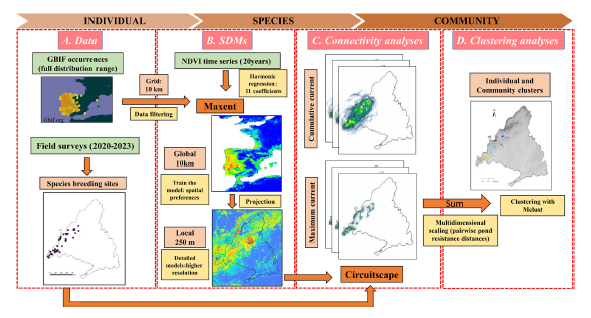
This work represents a milestone by applying an innovative methodology that integrates field data, species distribution models, and ecological connectivity analysis tools, such as circuit theory (Circuitscape 5.0).
What does this study entail?
Between 2020 and 2023, data were collected from over 2,300 water bodies distributed throughout the Community of Madrid, involving nearly 600 sampling sessions. In this way, the presence or absence of 16 native amphibian species was documented, grouped into 4 ecological communities (cosmopolitan, mountain, piedmont, and southeast), while evaluating connectivity patterns in the Community of Madrid.
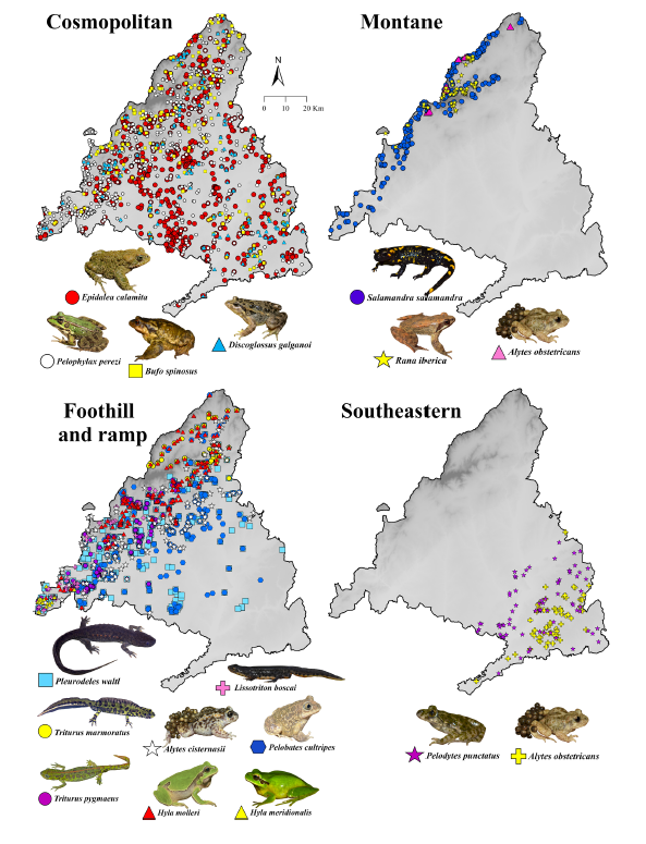
Based on this field database, species distribution models (SDMs) were developed to estimate the probability of presence for each species, taking into account environmental variables and remote sensing (NDVI). These models were used to calculate landscape resistance to amphibian dispersal, which is key to understanding which areas of the territory facilitate, hinder, or block their movement.
By applying circuit theory, population units were defined, and both dispersal routes and ecological barrierswere identified. This approach is especially useful in complex landscapes like that of Madrid, where infrastructure, terrain, and land use create fragmented connectivity patterns that can be applied to the design of specific censuses for this group and the environmental assessment of new projects.
Habitat fragmentation, which is particularly significant for species with low dispersal capabilities such as amphibians, affects population viability in a densely populated regional context.
Results
This study has collected data in a highly comprehensive and robust manner, with direct applicability to the conservation of the target species. It was conducted between 2020 and 2023, sampling more than 2,300 water bodies distributed throughout the Community of Madrid, with nearly 600 sampling sessions. In this way, the presence of 16 native species of amphibians was documented, grouped into 4 ecological communities (cosmopolitan, mountain, piedmont, and southeast), evaluating connectivity patterns in the Community of Madrid.
- The distribution models showed high statistical performance. Between 18 and 866 breeding sites were detected per species.
- Greater connectivity in mid-altitude zones and well-preserved natural areas (Sierra de Guadarrama).
- Low connectivity in dense urban areas, large bodies of water, old quarries, and areas with extreme terrain.
- We identified key barriers (urban infrastructure and artificial water bodies) and functional corridors (river valleys, peri-urban green zones, and mountain passes).
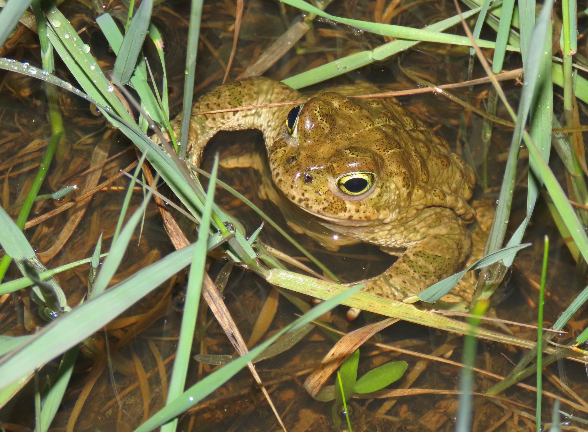
- Cosmopolitan species, such as Epidalea calamita or Pelophylax perezi, show higher connectivity compared to more sensitive species like Lissotriton boscai or Alytes obstetricans, which depend on very specific and well-preserved core areas.
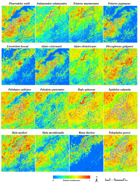
Ultimately, the results show a decrease in connectivity within urban and altered environments. Valleys, peri-urban green spaces, and natural passages between terrain elevations are identified as priorities. Overall, the approach of this study provides a powerful tool for decision-making in conservation, land-use planning, and the design of wildlife infrastructure.
Integrating field data and modeling has allowed for the precise identification of corridors and barriers, offering valuable results for land-use planning and concrete conservation measures.
Conclusions
Studies like this demonstrate the value of integrating all possible statistical tools into landscape connectivity models to improve the understanding of ecological processes, as:
- An innovative methodology is presented that combines intensive sampling, environmental modeling, and landscape connectivity.
- Human actions directly influence amphibian dispersal, limiting their mobility and increasing their vulnerability.
- Strategic areas for the conservation and restoration of ecological corridors are identified.
- The study provides a solid scientific basis to guide decisions in land-use planning, corridor design, habitat restoration, and wildlife crossing infrastructure.
- A low-cost, high-information-value analysis alternative.
- The importance of combining structural and functional connectivity through future genomic studies is emphasized, which will allow for a more realistic and effective understanding of biological connectivity.
This integrative approach emerges as a key tool for evidence-based conservation, especially in fragmented landscapes where many species face serious barriers to their survival.
Stay tuned to discover more scientific research driven and analyzed by the biodiversity team!
Bibliographic reference
Caballero-Díaz, C., Tarroso, P., Sánchez-Montes, G., Reyes-Moya, I., Polo-Cavia, N., and Martínez-Solano, Í. (2025). Connecting the dots: regional assessment of landscape connectivity in amphibian communities in Central Spain. Landscape Ecology, 40(8), 155. (view full publication)
.avif)
.jpeg)